Sim EFB - Create Advanced Flight Plan
Create Advanced Flight Plan
Sim EFB can be used in many ways. The Text Flight Plan left blank and Sim EFB used to display Maps/Charts, or simple flight plan can be entered, which is displayed in the “SIM EFB PANEL1” within FS2020.
With minimum of effort we can add collapsible sections using "+ My Heading"
And take this one step further by adding "+ Heading,Bearing,Altitude,Distance Nm" as can be seen in the example “EGKB EGKA Biggin Hill to Shoreham By Sea ”:
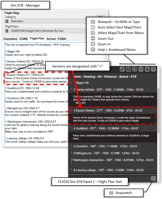
Sim EFB has calculated and add the Speed and ETE based on the values entered in the publish window.
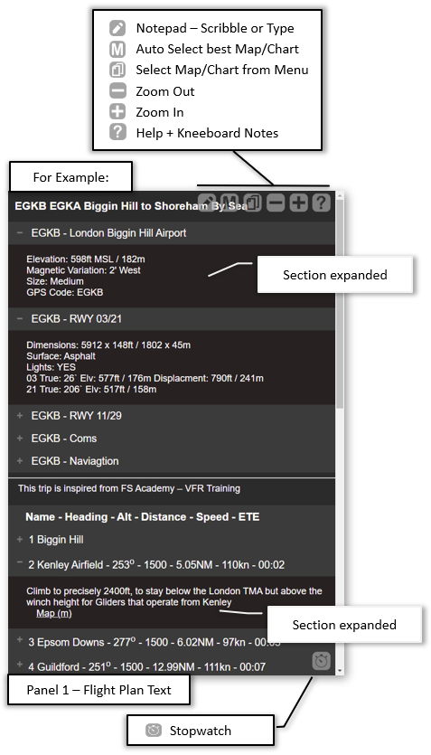
The three sections Departure/Arrival Airport + Flight Plan are displayed in FS2020 in sections:
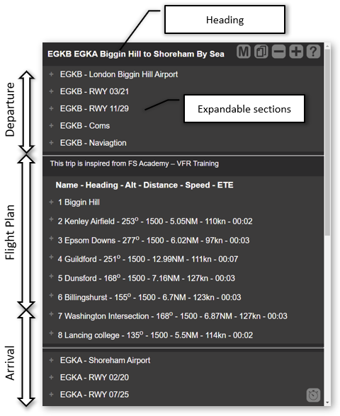
Each section can be expanded, by simply clicking on its heading, to read the section text:
Formatting Flight Plan
Flight plans are entered as simple text, but with the addition of a few extra codes at the start of the line, the formatting can be defined.
For example:
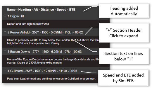
    Flight Plan

      + Biggin Hill


      Depart and turn right to follow 253


      + Kenley Airfield,253,1500,5.05


      Climb to precisely 2400ft, to stay below the London TMA but above the winch height for Gliders that operate from Kenley


      + Epsom Downs,277,1500,6.02,


      Home of the Epsom Derby horserace Locate the large Grandstands and the race course.  Cruise at 2300ft to give extra margin.


      + Guildford,251,1500,12.99


      Pass over Leatherhead and continue onwards to Guildford.  A large town.


      ...
Gives us:
The Flight Plan Notes can be formatted using, at the start of a line:
Add a Heading
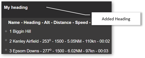
    Flight Plan

        h My heading


        + Biggin Hill


        Depart and turn right to follow 253`


        ...
Displays:
Adding a link to Map/Chart
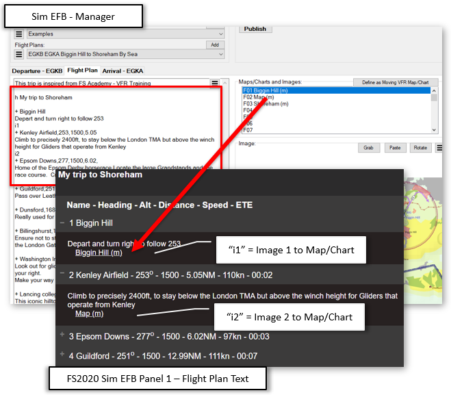
Links to Charts and Maps are automatically added as a list at the bottom of panel. But if you want to add a link to the image in the text you can do so:
        Add link to Map/Chart

      h My trip to Shoreham


  + Biggin Hill


  Depart and turn right to follow 253


  i1


  + Kenley Airfield,253,1500,5.05


  Climb to precisely 2400ft, to stay below the London TMA but above the winch height for Gliders that operate from Kenley


  i2


  + Epsom Downs,277,1500,6.02,


  Home of the Epsom Derby horserace Locate the large Grandstands and the race course.  Cruise at 2300ft to give extra margin.


  ...
Displays:
With specific co-ordinates
The flight plan can include specific co-ordinates.
    Example

      + Airport:EGLL,N51° 28' 16.40", W0° 27' 39.15",,0


OR


+ GPS:MAXIT,51.24972,-0.56194,=FL60,14

  ...
Indeed this can be show by importing a .PLN or .FLP file, or importing the current flight plan from FS2020.
This would give:
    Flight Plan

      h Flight : Heathrow to Alicante

      LowAlt Depart:27R MAXI1F Arival:28 REST2R CrAlt:FL220

      + Airport:EGLL,N51° 28' 16.40", W0° 27' 39.15",,0


      + SID:MAXI1F,N51° 28' 37.20", W0° 31' 49.82",>583ft,3

      Altitude 583ft Or Above

      RWY 27RIGHT

      Departure Flight Plan: MAXI1F RWY:27 RIGHT


      + SID:MAXI1F,N51° 27' 59.32", W0° 35' 44.18",>583ft,3

      RWY 27RIGHT

      Departure Flight Plan: MAXI1F RWY:27 RIGHT


      + SID:MAXI1F,N51° 23' 26.36", W0° 36' 4.20",>FL30,5

      Altitude FL30 Or Above

      RWY 27RIGHT

      Departure Flight Plan: MAXI1F RWY:27 RIGHT

  ...
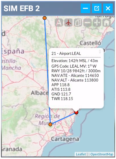
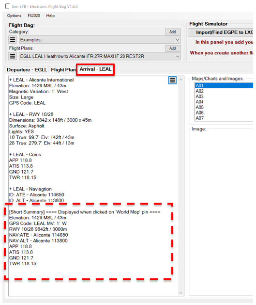
This allows Sim EFB to show the route on the "World Map"
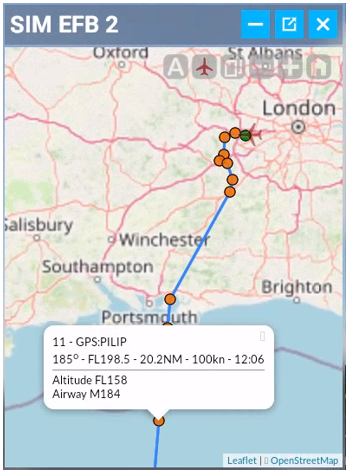
And the airport shows any text at the bottom of the airport, in this example LEAL
Shows as: